|
Shapes On The Landscape
Tilling and toiling has shaped these strips,
Tumbling terraces, ridges of ground,
These are the lynchettes the first farmers made
Shapes on the landscape are all around,
Shapes on the landscape are all around.
Deep in a disc the warriors sleep,
Bow, bell and berm - hallowed ground,
These are the barrows from Ages of Bronze,
Shapes on the landscape are all around,
Shapes on the landscape are all around.
Circles of stone, horses of chalk,
Castles and forts, mysterious mounds,
These are the wonders that welcome our gaze,
Shapes on the landscape are all around,
Shapes on the landscape are all around.
©Ashley Hutchings/Chris While
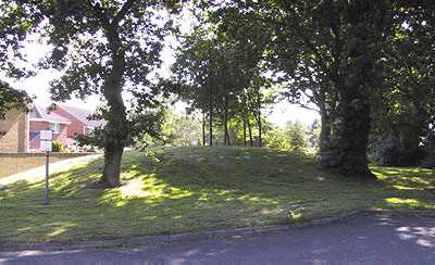
Barrows - Barrows were introduced during
the Beaker phase. They are a burial cist or grave covered with a mound of earth. They come in two styles; long barrows or
round barrows.
Long Barrows - Rectangular mounds of earth and/or stones used for
inhumations and cremation burials.
Round Barrows - A circular mound, which covers an inhumation or
cremation burial. Also known as Tumuli. These come in several sub-types:
Bell Barrows - Circular mounds which have a flat platform, before
the encircling ditch. They usually contain male burials.
Disc - A flat circular area, surrounded by both a ditch and a bank.
A small tump of earth in the centre marks the position of the grave itself. They usually contain female burials.
Bowl Barrows - Circular mounds which are sometimes accompanied
by a surrounding ditch.
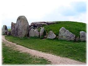
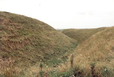
West Kennet Long Barrow - of which the burial chamber
is only a small part - stretches for 100 metres in an East - West orientation. The earth used in its construction was taken
from two trenches dug alongside the mound (see diagram), although these have long since become filled with weathered material.
The chamber, which extends 10 metres into the mound, consists of five seperate chambers, two on either side of a narrow passage
Berm: (noun)
1. A narrow ledge or shelf, as along the top or bottom of a
slope
2. A terrace formed by wave action along the backshore of a
beach
3. A mound or bank of earth, used especially as a barrier or
to provide insulation.
4. A ledge between the parapet and the moat in a fortification
Etymology: French berme, from Dutch berm, from Middle Dutch bærm,
berme.
source: Oxford English Dictionary
Cursus - A long, linear enclosure formed
by a parallel bank and/or ditch. They are thought to have been used for ceremonial processions, as like many megalithic monuments
they are aligned with the midsummer sunrise. The spread of these monuments is quite extensive. Examples have been found as
far apart as Norfolk and the Orkneys. Some of them run for miles across the landscape. The Dorset Cursus on Cranbourne Chase
runs for six miles and is the longest known. The name comes from the Latin for racecourse, as early investigators of these
monuments thought they were Roman structures used for chariot racing.
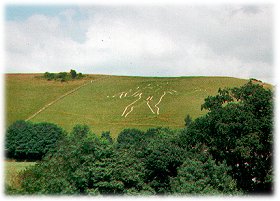
Hill Figures - Giant
figures of humans or animals, which are carved out of chalk hillsides in Southern England.
The Cerne Abbas Giant is the largest hillfigure
in Britain, he is one of two representations of the human form, the other being the
Long Man of Wilmington in East Sussex. The giant, carved in solid lines from the chalk bedrock measures
in at 180 feet high, and carries a huge knobbled club, which measures 120 feet in length
|
| part of the southern rampart. Maiden Castle, Dorset |
Hill Forts - These were, as the name suggests,
fortified defensive settlements on the top of hills. They were chiefly occupied by the Iron Age Celtic tribes, but some sites
had been in use since the Neolithic and some lasted well into the Roman period. The Celts updated the old wooden fortifications
by digging out large earth ramparts, which often wound mazelike around the settlement to confuse the enemy.
Maiden Hill Fort, a huge hillfort, that can be seen from
miles around, was in use in one form or another for something like 3500 years and consists of 3 separate occupation periods
and construction projects.
The first use of the site was during the Neolithic period. A causewayed enclosure consisting
of 2 banks 15 metres apart was constructed sometime between 3000-2000 BC at the eastern end of the hill enclosing an area
of about 8 hectares. About half a millennium later a 500 metre bank was built running northwest to southeast - the burials
of 2 young children were found beneath the eastern end.
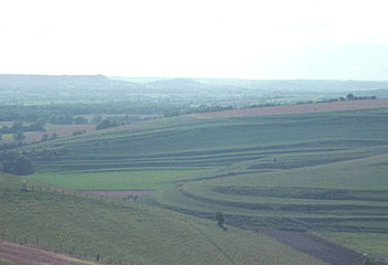
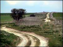
Lynchettes are created either unintentionally by ploughing
or intentionally in the hilly landscape to create terraces suitable for farming. This pressure for more agricultural land,
led to the creation of lynchettes, a form of terracing. Lynchette patterns can be seen in the above photograph.
Much of Butser Hill and sites on Holt and War Down have Scheduled
Ancient Monument Status as designated by English Heritage. These features include trackways, barrows, lynchets and the site
of a Roman farmstead.
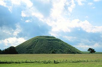
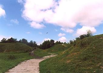
Silbury Hill, located just south of the village of Avebury in Wiltshire, is a massive artificial mound with a flat top. It is approximately
130 feet (40 m.) high, with a base circumference of 1640 feet. It is composed of over 12 million cubic feet (339,600 cubic
m.) of chalk and earth and covers over 5 acres (2 ha). Silbury Hill occupies a low-lying site and except at certain points
in the landscape, it does not protrude significantly above the horizon.
The Wiltshire stretch of the Ridgeway is the most remote section of the
entire route and runs along the ridge of archaeologically rich downland between Overton Hill and Uffington White Horse, on
the Oxfordshire borders.The route has been in constant use for 4000 years and some believe it continued beyond Wiltshire,
heading south into Dorset and on to the coast.
|
 |
|
A wooden boat thought to date
back more than 1,500 years
is to be raised from its
resting place on the
Hampshire coast.
from the BBC
An ancient British coin die -
used to create the design
on gold coins in
the Iron Age -
has been found
in Hampshire.
also from the BBC
this is the most incredible, most
comprehensive website on
Avebury Village and The Stones
anywhere on the internet.
A Must See!
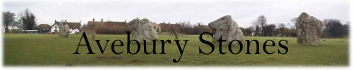
This is the site of the largest stone circle
in Europe.The circle is 335m across
with 98 stones remaining
ranging in height
from 2.1-5.5m (7-18ft).
High above Swindon, and
overlooking the modern metropolis
is one of Wiltshire's
Iron Age forts, Barbury Castle.
The stronghold comprises a
double line of earthworks,
occupying a four hectare site,
with entrances on its
eastern and western edges.
One of Barbury's attractions
is the view - the main reason why
Iron Age man chose to
occupy the site
2500 years ago
Littering the countryside
of the British Isles
are thousand upon
thousand of barrows.
They can be seen standing alone
on a windswept hill
or clustered together
in a farmers field.
Sometimes you will find
them miles from anywhere
on a deserted moor
and other times they might
stand beside a busy road.
For centuries they have been
steeped with legend
and folklore and, more often
than not, have been associated
with dark forces of magic.
What exactly is a barrow?
this site will answer some
of the questions.
an ancient farm reconstructed
in Hampshire.
A community Website for
the ancient village of
Cerne Abbas.
famous for its
Giant carved in the hillside
2000 years ago
the Roman Town of
Calleva Atrebatum
the BBC helps to excavate
this major achaeological find,
in Hampshire
Helen Mark of the BBC
visits this area of
Southern England
which straddles three
county boundaries: Dorset,
Wiltshire and Hampshire.
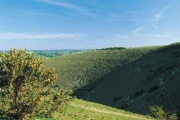
It is a rolling chalk landscape
with dramatic scarps and
steep-sided, sheltered valleys.
The area is rich in pre-historic
monuments, hillforts and
ancient burial mounds
called barrows.
It was a royal hunting ground
for centuries and, as a result,
remained almost untouched by
modern agriculture until the
mid-19th century.
The discovery and careful pinpointing
of a fabulous Bronze Age gold cup
in November 2001 by Cliff Bradshaw
has led to repeated investigations
of the site near Ringlemere.
all amount of history here,
absolutely fascinating stuff.
a prehistoric burial on
Salisbury Plain.
us the way.
The 1200+ photographs
of Dorset are divided across
two sets of galleries.
This one incredible site
an introduction to some of the
most fascinating relics of Britain's past,
from the world famous Stonehenge to the
little known Rempstone
and Knowlton Circles.
Wessex is one of the richest archaeological
landscapes in the world with forgotten roads,
crumbling castles, great cathedrals
and ancient burial grounds,
each with stories to tell.
The site is © 1997 - 2003 Phil Dunn
and a very fine job it is too.
Moonraking brings you a
multimedia mix of stories
concerning the mysterious
in Wiltshire and gives you
the chance to contribute
your ideas!
Chalk downland combines
gracefully
with low lying pastures while
Wiltshire's woodland and forests
are reminders of the
county's feudal past.
our website dedicated to
places of spirituality in England.
more shapes on the landscape
a celebration of the
tree and its offspring.
shaping the landscape
and another of our websites
The Downs, The Ridgeway
burial barrows, it's all here,
the very stuff of England
where urban and rural meet,
the natural beauty is not lost
lists from all over.
a valuable resource.
The history
of the Romans in Britain -
100BC to 450AD
Along
with insights into Roman life,
the military and
how the
Romans changed
Britain
a portrait of
Marlborough in Dorset
from our Rise Up Like The Sun
website
this valuable index is constantly being
added to and updated, so return often
Many ancient sites, from huge hillforts
to long barrows dating from Neolithic or
New Stone Age, can be found
in West Dorset.
Museum and Heritage Centre
West End, Hampshire, UK
A Sense of Place
the places and landscape
of Wiltshire, from Wiltshire's
version of this wonderfully
this site has an amazing 360 degree
panoramic shot of Stonehenge
|
Chalk downland combines gracefully with low lying pastures while Wiltshire's woodland and forests are reminders of the county's past. |
|
|
|
|
|
|
|
|
|
|
|
|